The surge of high water from Hurricane Irma was surprisingly low in some places like Tampa Bay, and surprisingly high in others like Jacksonville. Predicting surge is a tricky, new science.
Hurricane Irma swamped Jacksonville with 5 feet of water, but left Tampa unexpectedly dry — the opposite of what models had predicted for each city.
This is the first year the National Hurricane Center has offered flooding projections. But the storm defied these terrifying predictions of 10 to 15 feet of water above average sea level on Florida’s Gulf Coast, which triggered urgent evacuation calls on Saturday.
The discrepancies show the difficulty of predicting storm surges, particularly when a hurricane suddenly changes course.
“Certainly it was a very complicated storm surge story,” coastal geologist Robert Young of Western Carolina University told BuzzFeed News.
The storm hit the Keys as predicted, lost more steam there than anticipated, and then cruised along the Gulf Coast, instead of picking up any steam in the Gulf of Mexico before smashing back into land. That landfall on Marco Island came near Naples, Florida, where a high surge of 8 feet was reported, less than the 15 feet predicted. The storm’s high winds, meanwhile, stretched eastward to build up a low but persistent storm surge along the East Coast that has helped flood Jacksonville.
Although scientists only have tidal gauge data now, and a full accounting awaits field surveys in weeks ahead, the storm’s shifted track seems to explain the worst fears not coming to pass.
“The Keys really broke up the storm,” Young said. Its Category 3 label at its landfall on Sunday, he added, “really doesn’t do justice to how big this storm was and how wide its effects.”
Tampa Bay s prediction: Several feet of flooding in low-lying areas
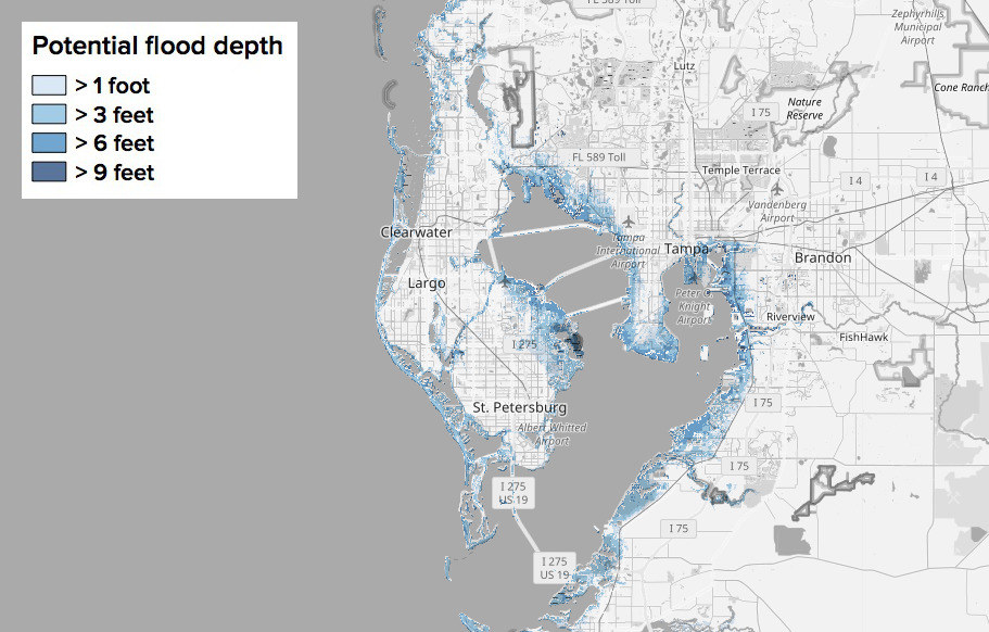
As late as Saturday, scientists were predicting that Irma would hammer Tampa Bay with a surge 5 to 8 ft above sea level, leading to just above 9 feet of flooding in some areas. As it turned out, the area saw essentially no flooding.
“As horribly damaging as Irma was, it was hardly a worse case scenario for much of western Florida,” MIT climate scientist Kerry Emanuel told BuzzFeed News by email. “In particular, had Irma stayed just offshore over the Gulf, it might have caused much larger storm surges north of Naples, and in particular, in Tampa Bay.”
A 2015 study co-written by Emanuel reported that such an offshore storm could generate a 32 foot surge in Tampa Bay. Instead Irma spared the city, making it, “comparatively lucky this time,” Emanuel said.
Not only did Tampa Bay not flood, but Sarasota Bay, just south, drained. Hurricane-force winds blew waters offshore leaving several manatees stranded in the mud, according to news reports. Volunteers rushed to water the marooned sea cows.
A similar draining was seen in the Bahamas, 360 miles to the east, illustrating Irma’s reach. Hurricane winds are actually strong enough to blow water out to sea in such a strong storm, sparking comparisons to tsunamis, but since those winds die down and shift direction gradually, the waters return slowly instead of sloshing back into place with the force of an earthquake driven tidal wave, Young said.
Jacksonville’s prediction: Almost no flooding
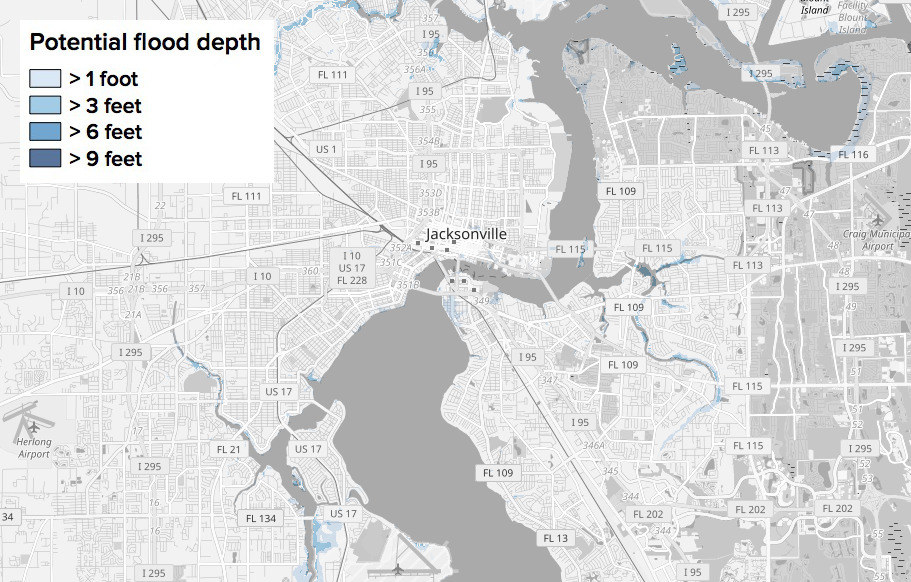
Hurricane Irma’s powerful winds ensured Florida’s east coast was pounded by a low but persistent storm surge, up to 3 feet high, which “chewed away” at beaches over the weekend, Young said. “It was more like a nor’easter than a hurricane.”
With only that short surge projected along the East Coast, the models didn’t encompass their added erosion of protective dunes, easing the way for an inundation.
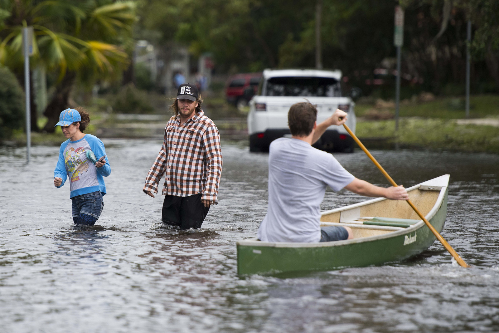
That storm surge rode atop a series of high tide cycles over the long term, apparently doing its damage to seawalls and dunes by erosion, not by overtopping them. In Jacksonville, the results were an unexpected, historic drenching of the city’s downtown.
This is Jacksonville... No words.
"The floodwaters are not going to recede today," Jacksonville Mayor Lenny Curry said Monday.
The city’s St. Johns River reached 5.22 feet above normal, surpassing the record of 4.1 feet set in 1965 during Hurricane Dora, according to the National Weather Service.
BEFORE AND AFTER | Memorial Park is underwater. Highest tides will hit downtown just before 2 p.m. Stay updated!
Disentangling the role of the storm surge from river flooding caused by rain in Jacksonville isn’t easy, Young said, as their effects are intertwined.
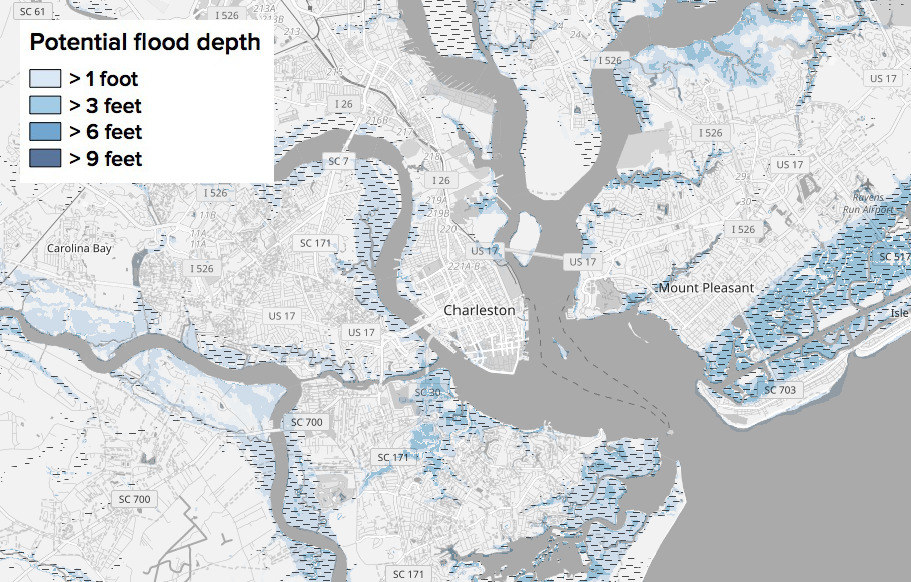
But a surprisingly strong surge has played out north of Florida: Charleston, South Carolina, saw flood waters higher than last year’s Hurricane Matthew, which had churned up the Atlantic Ocean on its travels.
Charleston’s prediction: Little flooding outside of coastal wetlands
Given that Florida is skinny, about 160 miles wide along much of the peninsula, disaster agencies may have to better coordinate the real-time response to storm surge shifts there, Princeton storm surge expert Ning Lin told BuzzFeed News. “When the storm comes, some areas’ near misses may become other areas’ direct hit.”
Given the zigs and zags of Irma, there’s no blame involved for experimental storm surge maps not nailing surge sizes a day ahead of landfall, Young said.
“For starters they put a big disclaimer up front that it is experimental,” he said. “And the truth is that you can only estimate storm surge once you have the track and the intensity of the storm confirmed, and nobody had that early enough.”
Comments
Post a Comment